Point Cloud Labeling: A Beginner's Guide to Annotating the 3D World

Point cloud labeling is one of the fastest-growing skills in data annotation — powering self-driving cars, robotics, and 3D mapping. This beginner's guide explains what point clouds are, how annotation works, the industries that rely on it, and the tools used to capture and label 3D data.
A Beginner's Guide to Annotating the 3D World
Imagine spinning a building around on your screen — every wall, pipe, and staircase rendered not as a drawing, but as a cloud of millions of glowing dots floating in exact 3D space. That's a point cloud: a laser-scanned replica of the real world, accurate down to the centimeter. The catch? To a computer, it's just dots. It has no idea which dots are a wall and which are a person standing next to it. Teaching it to tell the difference is a craft — and it's one of the most in-demand skills in data annotation today.
If you've ever wondered what point cloud labeling actually is, who pays for it, and what the work really looks like day to day, this guide walks you through it from the ground up..
What is a point cloud?
A point cloud is exactly what it sounds like: a collection of points in 3D space. Each point has a position (an X, Y, and Z coordinate) and often extra information like color, intensity, or how strongly it reflected a laser. Stack millions of these points together and you get a detailed 3D snapshot of a real scene — a street, a room, a building, a factory floor.
Unlike a flat photo, a point cloud preserves depth and geometry. You can rotate it, measure distances inside it, and understand how far one object sits from another. That's exactly what a robot or a self-driving system needs to navigate the real world safely.

What is point cloud labeling (annotation)?
A raw point cloud is just a mass of dots. The computer doesn't yet know that this cluster of points is a car, that one is a cyclist, and the flat region underneath is the road. Point cloud labeling (also called point cloud annotation) is the work of adding that meaning.
Annotators draw and tag objects inside the 3D scene so that machine learning models can learn to recognize them on their own. The most common techniques include:
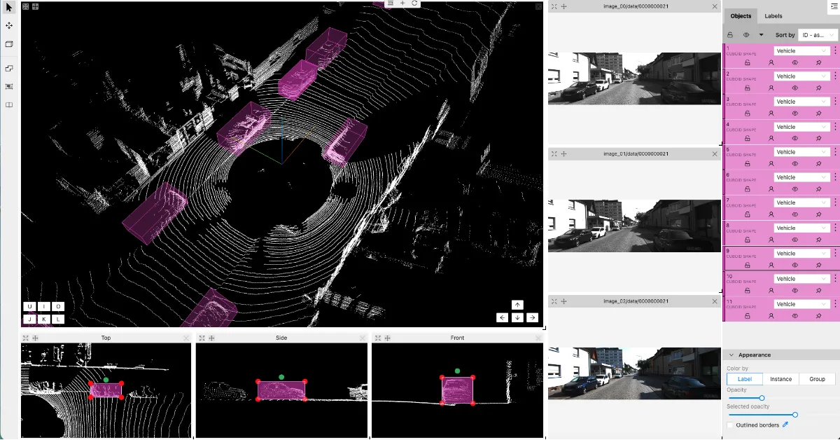
- 3D bounding boxes (cuboids): wrapping a tight 3D box around each object — a car, a person, a traffic cone — and tagging it with a category. This is the workhorse of autonomous-driving data.
- Semantic segmentation: labeling every single point by what it belongs to (road, sidewalk, vegetation, building, vehicle), so the whole scene is color-coded by meaning.
- Instance segmentation: going a step further to separate individual objects of the same type — telling car #1 apart from car #2.
- Object tracking across frames: following the same object as it moves through a sequence of point clouds over time, which is essential for predicting motion.
Done well, this labeled data becomes the "textbook" a model studies to learn how to perceive the world.
How different industries use it
Point cloud annotation quietly powers a surprising number of fields:
Autonomous vehicles and ADAS. This is the biggest driver of demand. Self-driving cars and driver-assistance systems rely on labeled 3D data to detect and predict the movement of vehicles, pedestrians, and cyclists.
Robotics and warehouse automation. Robots that pick, sort, and move goods need to understand the shape and position of objects around them. Labeled point clouds teach them what to grab and what to avoid.
Mapping, surveying, and smart cities. Cities and infrastructure firms scan roads, bridges, and entire neighborhoods to build precise 3D maps for planning, inspection, and digital twins.
Construction and architecture (BIM). Scanning a building or site produces a point cloud that can be labeled into walls, pipes, beams, and equipment — speeding up renovation, inspection, and progress tracking.

Agriculture and forestry. Drones scan fields and forests to measure crop height, count trees, or estimate yield.
Healthcare and AR/VR. 3D scans of the body or environment support surgical planning, prosthetics, and immersive experiences.
What tools capture point clouds?
The dots have to come from somewhere. A few core technologies do the capturing:
LiDAR (Light Detection and Ranging) is the star of the show. A LiDAR sensor fires rapid laser pulses and measures how long they take to bounce back, building a precise 3D map of its surroundings. You'll find it on self-driving cars, drones, and survey equipment. Spinning automotive units from makers like Velodyne, Ouster, and Hesai are common in the AV world.
Depth cameras and RGB-D sensors (such as Intel RealSense or Microsoft Azure Kinect) capture color and depth, and are popular in robotics and indoor scanning.
Photogrammetry builds a point cloud from many ordinary 2D photos taken at different angles — a lower-cost route used in mapping and cultural heritage.
Terrestrial and mobile laser scanners (from companies like Leica, FARO, and Trimble) are used for high-precision surveying of buildings, sites, and infrastructure.
Many advanced setups fuse several of these — for example, combining LiDAR with regular cameras so annotators can see both the 3D geometry and a familiar photo view side by side.
What does the labeling work actually look like?
Annotators work inside specialised software that lets them view, rotate, and slice through a 3D scene. A typical workflow looks like this:
First, the raw data is loaded and prepared — often as a sequence of frames captured over time, sometimes with synced camera images alongside.
Next comes the labeling itself: placing 3D cuboids around objects, or painting point-by-point segmentation, and tagging each with the correct category and attributes (for example, "car — parked" or "pedestrian — walking").
For sequences, annotators track objects across frames, keeping the same ID on a moving car from the moment it appears until it leaves the scene. Good tools assist with this through interpolation, so you don't have to redraw everything by hand.
Then the work goes through quality control — review passes that check for missed objects, loose boxes, wrong labels, or points assigned to the wrong class. Accuracy here is critical: a model is only as good as the data it learns from, so a tight, consistent label set directly affects how safely a system performs in the real world.
It's detail-oriented, spatially demanding work, and that's exactly why skilled point cloud annotators are valuable. It blends careful observation, an eye for geometry, and a real understanding of the objects you're labeling.
Ready to learn it properly?
Point cloud annotation sits at the intersection of two fast-growing fields — autonomous systems and AI data — and the demand for people who can do it well keeps climbing. The good news: you don't need an engineering degree to start. You need solid fundamentals, hands-on practice with the tools, and an understanding of what "good" looks like.
That's exactly what DeeLaba Academy's 3D Point Cloud Essentials course is built to give you — a practical, structured path from "what is a point cloud?" to confidently labeling 3D data to professional standards. If this world interests you, it's a great place to begin.
 Related course
3D Point Cloud Essentials
Build hands-on skill in 3D cuboid placement for autonomous vehicles and robotics.
Read more →
Related course
3D Point Cloud Essentials
Build hands-on skill in 3D cuboid placement for autonomous vehicles and robotics.
Read more →
Free newsletter
Data annotation insights, straight to your inbox
Career guides, industry news, and practical tips — sent only when worth your time. No spam.
Kari is the founder of DeeLab and also the founder & CEO of Tailjay, a Singapore-based venture builder operating globally. At DeeLab, Kari leads a growing team of professionals focused on high-quality data annotation and project-based su...
Ready to level up?
Explore our data annotation courses
Put these insights into practice with hands-on training built for aspiring data annotators and AI teams.
Explore related topics
Related Programmes